Showing posts with label Geography. Show all posts

Wednesday, 27 June 2018

Stamp's Classification of Climatic Regions


Stamp's Climatic Regionalization

Dr. L. Dudley Stamp's classification of Indian climate is very much akin to that suggested by W.G. Kendrew. This classification is empirical, arbitrary and subjective, but uses quantitative limits to the regions in easily understood units like temperature and rainfall. Stamp's schemes has been presented here with slight modifications here and there. Stamp used 18°C isotherm of mean monthly temperature for January to divide the country into two broad climatic regions, viz., temperate or continental zone in the north and tropical zone in the south. 

The two Major climatic regions are further divided into eleven depending upon the amount of rainfall and temperature.

 A. The Temperate on Continental India has been divided into following five region:

  1. The Himalayan region (heavy rainfall) 
  2. The north-western legion (modem, rainfall) 
  3. The arid low land 
  4. The region of moderate rainfall 
  5. The transitional tone

B. The tropical India has been divided Into following six regions :

  1. Region of very heavy rainfall 
  2. Region of heavy rainfall 
  3. Region of moderate rainfall 
  4. The Konkan Coast 
  5. The Malabar Coast 
  6. Tamil Nadu 


A. Climatic regions of temperate or continental India 

I. The Himalayan Region. 

This region embraces the entire Himalayan mountain area which includes from west to cast. Jammu and Kashmir, Himachal Pradesh, large parts of Uttarakhand, the north hill region of West Bengal. Sikkim and Arunachal Pradesh. The winter and summer temperatures are 4*-7°C and 13°-18°C respectively. The higher reaches are perpetually under snow and ice. The average annual rainfall exceeds 200 cm in the cast but it is much less in the west. Shimla in the west and Darjeeling in the cast arc its representative cities.

 2. The North-western Region. 

It includes the northern parts of Punjab and southern parts of Jammu and Kashmir. The winter and summer temperatures are 6°C and 24°C .respectively. Amritsar is its representative city. 

3. The Arid Lowland. 

This is a vast dry arts which includes the Thar desert of Rajasthan, south western pan of Haryana and Kachchh of Gujarat. The average temperature in winter varies from 16' to 24°C which may shoot up to 48°C in summer. Jaipur is representative city. The average annual rainfall does not exceed 40 cm. 


4. The region of moderate rainfall. 

Parts of in Haryana. western Uttar Pradesh. Union of Delhi. north-west Plateau area of Madhya Pradesh eastern Rajasthan are areas of average rainfall with an annual rainfall of 40 to 80 cm. Temperatures in January and July are 15°-18°C and respectively. Most of the rainfall occurs in summer. Delhi represents this region very well. 

5. The Transitional Zone. 

Eastern Uttar Pradesh and Bihar comprise the transitional zone between areas of average rainfall on the west and areas of heavy rainfall in the east. The average annual rainfall in this zone is 100-150 cm. The temperatures in January and July vary between 15'-19.C. and 35°C. Patna is the representative city of this zone. 


B. Climatic Regions of Tropical India 


6. Region of very heavy rainfall. 

These areas receive more than 200 cm of annual rain and include large pans of Meghalaya. Assam, Tripura, Mizoram and Nagaland. Temperatures remain around 18'C in January and the to 32-35' C in July. Cherrapunji and Mawsynram in Meghalaya receive 1,102 cm and 1,221 cm of annual rainfall respeaively.

7. Region of heavy rainfall. 

Chhattisgarh. Jharkhand Gangetic West Bengal and coastal Andhra Pradesh receive 100-200 cm annual rainfall and are termed as areas of heavy rainfall. The rainfall is primarily brought by the monsoon winds corning from the Bay of Bengal. The cyclones originating in the Bay of Bengal also bring some rainfall. The amount of rainfall decreases as we move from cast to west and from north to south. The January and July temperatures range from 18'-24°C to 29°-35'C respectively. Kolkata is the representative city of this region. 

8. Region of moderate rainfall. 

It includes mostly those areas between Western and Eastern Ghats which receive annual rainfall of 50-100 cm. Rainfall is comparatively low because this region lies in the rain shadow area of the Western Ghats. The average temperature in winter is 18°-24T which rises to 32°C in summer. This region is represented by Hyderabad in Telangana. 

9. The Konkan Coast.

Extending from Mumbai in the north to Goa in the south, the Konkan Coast receives over 200 cm annual rainfall brought by the Arabian Sea branch of the south-west monsoons. The temperature remains fairly high and varies from 24°-27°C. Thus the annual range of temperature is very low; to the tune of 3°C only. Mumbai is the representative city of this region. 


10. The Malabar Coast. 

It extent from Goa to Knnniyakumari and receives heavy annual rainfall of over 250 cm. The rainfall is mainly brought by the south-west monsoon winds coming from the Arabian Sea and continues for about nine months in a year. The temperature remains in the vicinity of 27°C and the annual range of temperature. This region is represented by Thiruvananthpuram. 

11. Tamil Nadu. 

It includes Tamil Nadu and  adjoining areas of Andhra Pradesh. The rainfall Varies from 100 to 150 cm and is mainly caused by retreating monsoons from north-East During  November and December. The temperature somewhere around 24'C. There is not much change in summer and winter temperature and the annual range of temperature is only 3' C . Chennai is representative of this region.


Thursday, 18 January 2018

Urban Heat Island


  causes , solutions ,pdf , mitigation ,ppt ,case study , upsc , urban heatland wikipedia

What is Urban Heat Island ?
                
The Urban Heat Island is an urban area that is significantly warmer than its surroundings rural area due ti its Human activities. This effect is known as urban heat island effect.


Reasons for the Formation of Urban Heat Island 

  1. Concentration of heavy vehicular and industrial pollution in urban Areas.

  2. Discharge of greenhouse gases (CHG.) in substantial amounts, which trap the outgoing infrared radiations. 

  3. Tall buildings and other Infrastructure which obstruct the flow of wind is, consequently obstructing the transfer of Heat. 

  4. Lack of vegetation in urban areas which acts as heat and carbon sink. 

  5.  Majority of urban surfaces are composed of metals, glass, concrete or asphalt. These materials have high heat-retaining capacity during the day and emit this heat out during the night. 

  6. The inability of water to penetrate the above materials makes the urban landscape behave as desert landscape. 
Effects of UHIs 

  1. UHI have the potential to directly affect the health of urban  residents. UHI witness prolonged heat waves which result in  higher fatalities due to heat stroke,exhaustion heatcramps, etc. 

  2. UHI have varied effects on biodiversity. The variation In temperatures adversely affect local species and promote the invasion of alien species.

  3.  The raised temperature may elevate the temperature of local water bodies causing the aquatic animals to undergo thermal stress and shock. 

  4. The increased temperatures provide fertile breeding ground for insects, which bring a host of diseases along with them. 

  5. UHI create a spike in energy consumption duo to higher use of refrigerated air  conditionals. 

  6. UHI can alter load weather conditions arch as wind, Humidity,  and rainfall
Mitigation Strategies 

  1. The effects of UHI can he diluted to some Extend  by applying  techniques to maintain a large albedo. Larger albedo means higher  ability to reflect radiations. The buildings and ether dark Surfaces (asphalt) could be painted with a light colour or with a high reflective coating. 

  2. Green roofs (roofs with plants and vegetation) on top of buildings help lower down the temperature and compensate to some extent for the loss of vegetation. Beside green roof, roof sprinklers in reducing temperature of evaporation. 

  3. Increasing area wider natural vegetation and reclaiming waste lands to develop green belts may also help in reducing the effects of UHl.

  4. While deciding urban architecture, wind flow should be given priority. Urban architecture should be least detrimental to natural Wind flow. 


Thursday, 4 January 2018

Scientists identify four new balsam species

Throwing fresh light on the uncharted biodiversity in India’s north­eastern region, researchers from the University of Calicut in Kerala have reported the discovery of four new species of balsam from various locations in Arunachal Pradesh.  The team came across the new species while scouring the Eastern Himalayas as part of an expedition supported by the Department of Science and Technology and the International Association for Plant Taxonomy, Slovakia. Commonly known as jewel weeds because of the diverse colour of the owers, balsams are distributed throughout the Eastern Himalayas and the Western Ghats, Sri Lanka, South East Asia, Africa and Madagascar. The genus is called  Impatiens, signifying the impatient nature of the fruits which explode when touched. The researchers have published their ndings in the international journals Phytotaxa and Webbia.  Reported from Pongchan, Impatiens haridasanii was named after Haridasan, former scientist, State Forest Research Institute, Arunachal Pradesh, for his contribution to the taxonomy of the north­eastern States. The species is characterised by small yellow owers and hairy leaves. Impatiens pseudocitrina, discovered in Anjaw district, sports bright yellow owers with small red spots on the throat and a long spur at the back. The species name denotes the similarities with I. citrina. A magnicent species discovered from the Lower Dibang valley, Impatiens nilalohitae grows to a height of more than one metre and has dark purple owers with pale yellow throat and green stalk. The name  nilalohitae denotes the dark purple colour in Sanskrit.  Another spectacular balsam, I. roingensis, was found growing in Roing and Upper Siang. The plant has clustered white owers with yellow patch on the mouth and hooked spur.  According to the authors, road widening works, deforestation and other development activities are posing a threat to the natural habitat of the new species.  The researchers have also reported the rediscovery of another species  I. agastyamalayensis from the Western Ghats after a gap of more than a century.  India is home to more than 230 balsam species.  Earlier, scientists had reported the discovery of Impatiens arunachalensis, a critically endangered species, from the Upper Siang district. Another balsam species Impatiens walongensis has been reported from Anjaw district.  

Thursday, 28 December 2017

Mission Seven Summits


What is it? After scaling of Mt Everest in 2005, IAF launched a unique and unprecedented series of mountaineering expedition ‘Mission Seven Summits’ with an aim to fly the tricolour and the IAF flag on the highest peaks in every continent. With this, the IAF has become the first organisation in India to achieve this unique feat.
The highest peak on each continent – Asia Mt. Everest, Australia Mt. Kosciuszko, South America Mt. Aconcagua, Antarctica Mt. Vinson Massif, North America Mt. Denali, Europe Mt. Elbrus and Africa Mt. Kilimanjaro – are part of Misson7Summit.

Saturday, 2 December 2017

Tropic of Capricorn passes through

Countries that the Tropic of Capricorn passes through

The Tropic of Capricorn (or the Southern Tropic) is the circle of latitude that contains the sub solar point on the December (or southern) solstice. It is thus the southernmost latitude where the Sun can be directly overhead. Its northern equivalent is the Tropic of Cancer.
There are 10 countries, 3 continents and 3 water bodies lies on Tropic of Capricorn passes.
South America
Argentina, Brazil, Chile Paraguay
Africa
Namibia, Botswana, South Africa, Mozambique, Madagascar
Australia
Australia
Water Bodies
Indian Ocean, Atlantic Ocean, Pacific Ocean


see also -

  1. Prime Meridian passes through
  2. Equator Passes Through
  3. Tropic of Cancer Passes Through
  4. The Countries Bordering to Red Sea
  5. The Countries bordering the Mediterranean sea

Prime Meridian passes through

Prime Meridian passes through following countries :-
1- United Kingdom( Greenwich, London)
2- France
3- Spain
4- Algeria
5- Mali
6- Burkena Faso
7- Togo
8- Ghana

See also -


  1. Tropic of Capricorn passes through
  2. Prime Meridian passes through
  3. Equator Passes Through
  4. Tropic of Cancer Passes Through
  5. The Countries Bordering to Red Sea
  6. The Countries bordering the Mediterranean sea

Equator Passes Through


  1. Ecuador
  2. Columbia
  3. Brazil
  4. Gabon
  5. Congo
  6. Democratic Republic of Congo
  7. Uganda
  8. Kenya
  9. Somalia
  10. Maldives
  11. Indonesia
  12. Kiribati
  13. Soa Tome & Principe
Africa is the only continent through which the Equator , tropic of cancer , tropic of Capricorn and prime meridian.

See also 


  1. Tropic of Capricorn passes through
  2. Prime Meridian passes through
  3. Equator Passes Through
  4. Tropic of Cancer Passes Through
  5. The Countries Bordering to Red Sea
  6. The Countries bordering the Mediterranean sea


Tropic of Cancer Passes Through

1-Mexico
2- Bahamas
3-Western Sahara
4- Mauritania
5- Mali
6-Algeria
7-Niger
8- Libya
9- Egypt
10- Saudi Arabia
11- U.A.E
12-Oman
13- India
14- Bangladesh
15- Myanmar
16- China

Sunday, 19 November 2017

Gradient mapping

Gradient fingerprint mapping is a new tool developed by scientists to predict the state of coastal cities during an event of mass melting of land ice from Antarctica and Greenland. The study published in Science Advances analysed 293 major port cities and found New York, London and Sydney are all vulnerable

Monday, 13 November 2017

What is the Pacific shadow ­zone?

The shadow zone is an area of almost stagnant water sitting between rising currents caused by the rough topography and geothermal heat sources below 2.5 kilometers and shallower wind driven currents closer to the surface in the North Pacific. 

This is the oldest water in the ocean in the North Pacific and has remained trapped in a shadow zone around 2 kilometers below the sea surface for over 1,000 years. 

Until recently, models of deep ocean circulation did not accurately account for the constraint of the ocean floor on bottom waters. 

Once the international team of researchers precisely factored it they found the bottom water cannot rise above 2.5 km below the surface, leaving the region directly above isolated. “Carbon 14 dating had already told us the most ancient water lay in the deep North Pacific.

 But until now we had struggled to understand why the very oldest waters huddle around the depth of 2 km,” said lead author from the University of New South Wales, Dr. Casimir de Lavergne. “What we have found is that at around 2 km below the surface of the Indian and Pacificc Oceans there is a ‘shadow zone’ with barely any vertical movement that suspends ocean water in an area for centuries.” The article, “Abyssal ocean overturning shaped by sea floor distribution”, has been published in the journal, Nature.

Monday, 16 October 2017

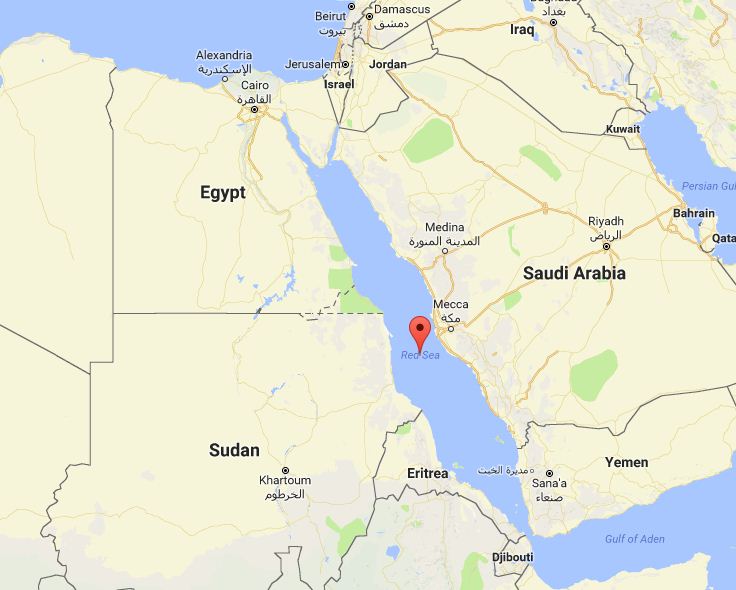
The Countries Bordering to Red Sea

The Red Sea, one of the most saline bodies of water in the world, is an inlet of the Indian Ocean between Africa and Asia. The connection to the ocean is in the south through the Bab el Mandeb sound and the Gulf of Aden. In the north are the Sinai Peninsula, the Gulf of Aqaba, and the Gulf of Suez (leading to the Suez Canal). The Sea has played a crucial navigational role since ancient times.
Occupying a part of the Great Rift Valley, the Red Sea has a surface area of about 174,000 square miles (450,000 km²): Being roughly 1,200 miles (1,900 km) long and, at its widest point, over 190 miles (300 km) wide. It has a maximum depth of 8,200 feet (2,500 m) in the central median trench and an average depth of 1,640 feet (500 m), but there are also extensive shallow shelves, noted for their marine life and corals. This, the world's most northern tropical sea, is the habitat of over 1,000 invertebrate species and 200 soft and hard corals.


  • Northern shore:
    • Egypt
    • Israel
    • Jordan
  • Eastern shore:
    • Saudi Arabia
    • Yemen
  • Western shore:
    • Sudan
    • Egypt
    • Eritrea
  • Southern shore:
    • Djibouti
    • Eritrea

See also - The Countries bordering the Mediterranean sea

Saturday, 14 October 2017

Sunday, 10 September 2017

9th Sept Daily current affairs for UPSC Civil Service Exam

Fuel from Air
  • Scientists have found a way to produce methanol using oxygen in the air.
  • Methanol is an important chemical used as fuel in vehicles.
  • It is currently produced by ‘Methanol Synthesis’ process which is very expensive and energy intensive.
  • It involves breaking down natural gas at high temperatures into hydrogen gas and carbon monoxide.
  • But the new process uses oxygen, a ‘free’ product in the air and combines it with hydrogen peroxide at mild temperatures which require less energy.
  • It is seen as an advance that may lead to cleaner, greener industrial processes worldwide.
Pluto Mountains
  • Two mountain ranges on Pluto have been named after Tenzing Norgay and Edmund Hillary respectively by the International Astronomical Union (IAU).
  • These are the first geological features on the planet to be named following the close flyby by the New Horizons spacecraft in July 2015.
  • IAU has officially approved the naming of 14 features on the dwarf planet for the first time.
  • IAU is the internationally recognised authority for naming celestial bodies and their surface features.
  • Tenzing Norgay and Sir Edmund Hillary were the first to reach the summit of Mount Everest and return safely.
West Bengal to Bangla
  • West Bengal cabinet has approved changing State’s name to Bangla.
  • The state had earlier proposed that West Bengal be named Bangla in Bengali, Bangal in Hindi and Bengal in English.
  • But the Centre rejected the proposal of having 3 names in 3 different languages and state is compelled to have “Bangla” as the new name.
  • According to the Indian Constitution, the power of changing the name of the State lies with the Centre.
  • The Article 3 of the Constitution deals with the formation of new States and alteration of areas, boundaries or names of existing States.
  • It says that Parliament may by law,
    1. form a new State by separation of territory from any State or by uniting two or more States or parts of States or by uniting any territory to a part of any State;
    2. increase the area of any State;
    3. diminish the area of any State;
    4. alter the boundaries of any State;
    5. alter the name of any State;
Sahara Forest Project
  • Jordan has launched “Sahara Forest Project” to turn its sand dunes into farming land to produce food using sun and sea water.
  • The project is funded by Norway and the European Union.
  • It will use solar panels to provide power and include outdoor planting space, two saltwater-cooled greenhouses, a water desalination unit and salt ponds for salt production.
  • Jordan is a water poor country that is 90% desert, located on the east bank of Jordan River in West Asia.
  • It is bordered by Saudi Arabia to the east and south; Iraq to the north-east; Syria to the north; Israel, Palestine and the Dead Sea to the west; and the Red Sea in its extreme south-west.

    International Literacy Day
    • International Literacy Day is celebrated on 8th September every year by UNESCO.
    • This day marks the meeting of the world congress of Ministers of Education in Tehran for the first time in 1965 to discuss the programme of education at the international level.
    • The UNESCO in its 14th Session in November, 1966, declared 8th September as the International Literacy Day.
    • The theme of this year is `Literacy in a digital world’.
    Hurricane Irma
    • Irma is a powerful category 5 Hurricane in the Atlantic Ocean.
    • It is second major hurricane of the 2017 Atlantic hurricane season after Hurricane Harvey.
    • It has a maximum sustained wind speed of 160 miles per hour.
    • It made landfall in Cuba's Camaguey Archipelago, caused devastation in Carribean islands and heading towards Florida, US.
    • It achieved one of the longest durations of Category 5 strength winds ever on record.
    • It is the strongest hurricane ever to form in the Atlantic Ocean outside of the Gulf of Mexico and Caribbean Sea.

What are El Niño and La Niña events?

El Niño and La Niña events are a natural part of the global climate system. They occur when the Pacific Ocean and the atmosphere above it change from their neutral ('normal') state for several seasons. El Niño events are associated with a warming of the central and eastern tropical Pacific, while La Niña events are the reverse, with a sustained cooling of these same areas.

These changes in the Pacific Ocean and its overlying atmosphere occur in a cycle known as the El Niño–Southern Oscillation (ENSO). The atmosphere and ocean interact, reinforcing each other and creating a 'feedback loop' which amplifies small changes in the state of the ocean into an ENSO event. When it is clear that the ocean and atmosphere are fully coupled an ENSO event is considered established.

Even in a neutral state, temperatures in the Pacific Ocean vary from east to west – for example, the western Pacific 'warm pool' in the tropical Pacific has some of the warmest large-scale ocean temperatures in the world. During an ENSO event, ocean temperatures become warmer than usual or cooler than usual at different locations, which are reflected in ocean temperature gradients. The most important driver of ENSO is these temperature gradients across the Pacific, both at the surface and below the surface, particularly at the thermocline.


Pacific Ocean – even in neutral state the Western Pacific is warm

Why are they called El Niño and La Niña?

The term El Niño translates from Spanish as 'the boy-child'. Peruvian fishermen originally used the term to describe the appearance, around Christmas, of a warm ocean current off the South American coast. It is now the commonly accepted term to describe the warming of the central and eastern tropical Pacific Ocean. La Niña translates as 'girl-child' and is the opposite ENSO phase to El Niño.

Coupled

Because ENSO involves interaction between the ocean and the atmosphere – both of which play a role in reinforcing changes in each other – it is known as a coupled ocean–atmosphere phenomenon.


ENSO impacts 

rainfall

The complex interactions between the ocean, atmosphere and adjacent landmasses across the Pacific mean that ENSO events have impacts on weather in areas outside the tropical Pacific region. El Niño and La Niña events are associated with distinct climatic conditions around the Pacific.
La Niña events are associated with greater convection over the warmer ocean to Australia's north. Typically this leads to higher than average rainfall across much of Australia, particularly inland eastern and northern regions, sometimes causing floods.
During El Niño events, the ocean near Australia is cooler than usual, bringing lower than average winter–spring rainfall over eastern and northern Australia. Although most major Australian droughts have been associated with El Niño events, widespread drought is certainly not guaranteed when an El Niño is present.

Rainfall patterns during La Niña and El Niño events


Australian rainfall data for 13 of the strongest 'classic' or 'canonical' events (having the typical autumn to autumn pattern of evolution and decay) since 1900 have been combined to form a composite of average impacts of La Niña and El Niño events upon rainfall across Australia.
Each map shows mean rainfall deciles, where green to blue tones indicate above-average to very much above-average rainfall totals and yellow to red tones indicate below-average to very much below-average rainfall. Note that the rainfall patterns can vary significantly from one event to the next.


El Niño

El Niño is typically associated with reduced rainfall northern and eastern Ausintralia.

La Niña

La Niña is typically associated with increased rainfall in northern and eastern Australia.


Thermocline

Thermocline comes from the Greek for 'heat slope' and is the name for the region separating warm, well-mixed surface water from cool, deep ocean water. Typically water temperatures above the thermocline are more than 25°C while those below the thermocline are 15°C or less.


The El Niño–Southern Oscillation (ENSO) is described in more detail in the section The three phases of ENSO.